
Coastal Plan for the Šibenik-Knin County, a path towards resilience and sustainability
Geographic context and climate challenges
The Šibenik-Knin County of Croatia has an exceptionally indented coast, 960 km long, with 285 islands, islets and rocks. The County is rich in natural resources and biodiversity, with two national parks, Krka estuary and Kornati archipelago. Its coastal zone consists of seven municipalities and three cities including Šibenik, the administrative centre. Over the past few decades, increasing coastal urbanization in its coastal zone resulted in pressures on the space, water resources and sustainable development in general. From 1950s onwards there has been a constant decrease in the number of the population living in the County’s hinterland and the rise in the population of the coastal cities, especially settlements by the sea.
Negative demographic trends, reflected in a recent drop in population numbers in the entire County, have not resulted in reduced construction in the coastal settlements, due to a significant increase in secondary housing. Consequently, the coastal settlements experience a constant drop in the share of residential housing in the total housing number.
Spatial plans allow for equal share of built-up area in the first km of the County’s coastal strip as in France or Italy (data from 2000). However, the French Mediterranean coast has up to 10 times higher population density. Large exposure of the highly urbanized coast to sea level rise and coastal floods represents a high risk for the County.
The most important climate change impacts considered in the Coastal Plan were: growth of air temperatures, changes in the precipitation regime, changes in the wind regime, elevated sea levels, higher sea surface temperature, increased salinity of the sea and changes in storm surges and tides. The values used were obtained on the basis of several regional climate models (Croatian Meteorological and Hydrological Service, ICTP, CNRS-GAME) and are presented in the table below:
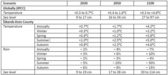
Values of global temperature and precipitation changes and estimated trends for the Šibenik-Knin County
Another important issue for the future of the area is water and water infrastructure. This area, extremely rich in water during winter, becomes poor in water in summer, when the need for water is largest. Among others, the existence of one of the most valuable natural phenomena of the region, a large travertine barrier (among the longest in the EU) depends on the biological minimum of the water of the Krka River.
Among the key risks for the region, the stakeholders identified the threat of the forest fires. Namely, this green region of the Croatian coast has among the highest values of the forest fire risk indices.
Objectives
The main objectives of the Coastal Plan were to:
- define a management system for coastal areas which can ensure the building of resilience of coastal systems to the impacts of climate variability and change, and direct development towards sustainability;
- identify particularly endangered areas with regard to coastal processes, especially areas vulnerable to the impacts of climate variability and change;
- propose measures for the definition of a policy for the adaptation to the impacts of climate variability and change; and
- provide assistance in the formulation of sectoral policies and plans, and their integration in the policy of the sustainable development of the coastal area.
Adaptation measures implemented in the case
Adaptation through ICZM plans
Solutions
The development of the Coastal Plan for the Šibenik-Knin County was part of a larger UNEP/GEF Medpartnership project. It was developed on the basis of the Mediterranean Protocol on Integrated Coastal Zone Management (ICZM), and backed up by the County spatial plan. The preparation process was launched in 2013, with the plan finalized by the end of 2015 and adopted by the County Assembly in April 2016. Among the Project activities several were designed to contribute to the Coastal Plan, such as:
- Assessment of costs of sea-level rise in the Republic of Croatia using DIVA method;
- Climagine participatory method; and
- Local assessment of vulnerability to climate variability and change.
The Coastal Plan was prepared using the typical ICZM planning process, following the ecosystem approach that considers the complexity and interdependence of the ecosystem elements for achieving ecological, social, economic and management goals.
The territorial coverage was determined according to the Croatian Law on the ICZM Protocol ratification, as follows:
- on land it encompasses all local administrative units bordering the sea;
- at sea it encompasses the area to the outer borders of the territorial sea (12 nautical miles from the shoreline).
Following the ecosystem approach, the plan encompasses the Krka river basin as well.
During the establishment stage the key stakes for the sustainable development of the coastal zone were identified as climate change and variability impacts, coastal space and water resources. These three themes were assessed through more detailed studies, where all the findings contributed to the cumulative vulnerability assessment. Wildfire risks were identified by the stakeholders as the closest risk in time, while coastal flooding combined with heavy rains and flash floods were identified as the major cause of costs expected from the climate change impacts in the project area.
The Plan proposed four policy groups referring to resilience of the narrow coastal belt, sustainable spatial development, water management and sustainable economic development (focusing on mitigation). In addition, the management system for the coastal zone was proposed within which a County Committee for integrated coastal and marine management was established.
The proposed measures for the coastal space are aimed at preserving the remaining part of the natural coast, improving the quality of the built-up coast, concentrating the urban zones, preventing scattered and linear shoreline construction. After the adoption of the Coastal Plan, among the activities aiming to preserve the remaining natural coast, the County developed the spatial plan of the area of the Žut-Sit islands, which is the first time in Croatia that an area protected owing to its landscape values got its own spatial plan. The County assembly adopted this spatial plan in 2019 with the aim of securing sustainable development of this precious protected and inhabited coastal space. An active participatory approach was used to formulate this spatial plan, based on the good experiences with the development of the Coastal Plan. The vulnerability analysis undertaken within the Coastal Plan revealed zones exposed to sea flooding, and the plan recommended avoiding construction in those zones, as well as in the immediate vicinity of the sea in general. These measures serve to all future spatial plan revisions. The Coastal Plan identified the need to add a GIS specialist to the County staff and to continue building the GIS database completed during its preparation. A GIS specialist was hired in 2018 as a permanent member of the County staff. The Coastal Plan identified the need to prepare a marine spatial planning (MSP) for the region. Within the Adriadapt project the County is preparing an MSP input study focusing on the impacts of climate change. Earlier, in 2018, a study “Mapping of the resources for aquaculture” was completed.
The measures proposed for water should ensure that the climate change effects do not endanger the available quantity and quality of water for all purposes, to keep or improve the quality of wastewater disposal, to secure protection against flooding and droughts, and to ensure the quality of water infrastructure management. It is of particular importance to ensure an integrated approach to all the waters of the Krka river basin and the coastal zone as it is a prerequisite for achieving the set goals.
The measures related to enhancing resilience included the measures for the narrow coastal belt, aiming at adaptation of coastal infrastructure to increased extreme weather events and sea level rise. The Coastal Plan recommended including these considerations into planning of any coastal intervention. It identified the areas most vulnerable to flooding, two of which made significant progress in preparing technical documentation for the adaptation of their waterfronts (Dolac zone of Šibenik, and Vodice town) in the recent period. The Port Authority applied for several new harbours, with the EIA study now taking climate change impacts into consideration, which was not the case before the Coastal Plan.
Measures were recommended for forest fires, as well as for various economy sectors, (tourism, agriculture, aquaculture, etc.), as well as for biodiversity, health and cultural heritage. Considerable progress has been made in the field of fire protection, through several projects and in collaboration with the Croatian Forests. As of 2020 95% of the County territory is covered by surveillance cameras. Regarding agriculture, a priority measure, development of irrigation system, is in course with works on two accumulations starting in collaboration with the Croatian Waters. A big accumulation project was abandoned following the results of the EIA study. Decision has been taken, in line with the Coastal Plan, to focus on small accumulations. A hydrogeological study for new small accumulations is being developed.
Finally, measures were recommended for the energy sector promoting local production from renewable sources and warning of the future reduction of water available for hydro energy production. Measures directed at traffic referred to the promotion of ecologically acceptable mobility concepts. Recommendations for economy aim at ensuring a balanced local economy with the strong local production, since consuming local products reduces traffic emissions and prepares the region for the expected future CO2 tax.
Leader of the initiative and key partners
Once the Coastal Plan was completed and adopted by the County Assembly, the Šibenik-Knin County remained the leader of the initiative, with the newly established County committee for coastal and marine management led by the County Prefect personally and with the Head of the Department for Environmental Protection and Municipal Affairs acting as Secretary. The Committee consists of the representatives of 11 organizations with major stakes in the coastal and marine issues. This body meets as need occurs, but not less than once a year, to coordinate the implementation of the Coastal Plan. However, the Coastal Plan is aimed at supporting green governance in the County. Therefore, all segments of the society may find relevant recommendations inside this document. PAP/RAC, the organization that led the preparation of the Coastal Plan, continues to provide support to the County Government participating to the County Committee meetings and jointly implementing other projects, such as Adriadapt.
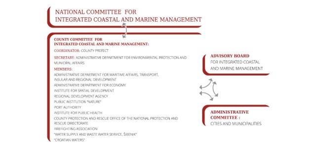
County Committee for integrated coastal and marine management
Coastal infrastructure cadastre
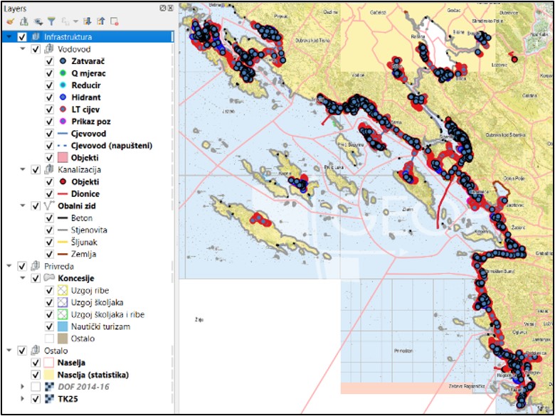
One of the priority actions from the Coastal Plan was the development of the Coastal infrastructure cadastre (within the AdriAdapt project). Namely, due to the extremely complex division of the competences along the coastline, as well as the fact that jurisdictions during extreme circumstances are different than the ones in the regular times, the need for the database of all potential sources of pollution, as well as the state of the coastal infrastructure, appeared as essential tool for coastal management.
In order to develop the methodology for the Cadastre of coastal infrastructure the analysis of the vulnerability of coastal infrastructure and of the vulnerability of coastal sea has been developed. In order to understand potential threats from the changing climate as well as how to increase coastal resilience it was necessary first to understand in detail all existing infrastructure and its potential behavior under the climate change impacts. Whole process has been captured through 8 documents, (including summary) among which the analysis of the coastal infrastructure vulnerability also provides solutions for planning of coastal infrastructure resilience. All documentation is currently in local language and is available upon request.
Stakeholder participation
As the participatory approach lies in the heart of the ICZM, a participatory process represented an important axis of the preparation of the Plan. It was implemented in parallel with the drawing of the Plan, through the participative method “Climagine“. In the establishment stage a Stakeholder analysis was developed, based on which some 100 stakeholders were identified and invited to all Climagine workshops. Through recognising and questioning the previous, present and future levels of sustainability of the project area, the stakeholders verified the expert’s findings and weaved their local knowledge and desires into the Coastal Plan. In the course of four workshops, 50-odd local actors discussed critical issues of the Šibenik-Knin County coastal development, agreed on the joint vision, and jointly sought solutions to enhance sustainability and resilience of the coastal area. At each workshop Coastal Plan experts presented their findings and discussed them with the stakeholders. In addition, each workshop was enriched by the introductory lecture about some of the challenges that climate change is bringing to the local community. In addition to workshops, approximately 30 interviews were held with the key stakeholders. These activities improved the quality and secured local ownership of the Coastal Plan, but also improved the knowledge and awareness of the local community related to climate change, its impacts and the climate action needed.
Once finalized, the Plan was presented to various stakeholder groups in the region, in the country and around the Mediterranean. The intention to establish an Advisory Board composed of the most active stakeholders from the Plan’s preparation process hasn’t been realized yet, but it is not abandoned. It will be renewed during the implementation of the Adriadapt activities.
Success and limiting factors
The key factors for the success of the Coastal Plan may be identified as follows:
- a strong political support expressed by the County Prefect who closely followed the process, participated actively in meetings/workshops together with the key personnel of the County institutions, and by doing so enabled the creation of a feeling of ownership and contributed to the trust of the stakeholders that the Plan would be successfully implemented;
- a successful participatory process which enabled the creation of the sense of urgency for climate action, embracing the local knowledge and desires into the Plan and consequently developing ownership of the Plan by the stakeholders;
- a committed approach of the team of experts led by PAP/RAC that resulted in a high-quality document, and a continuous support of PAP/RAC during the implementation of the Coastal Plan.
At the ECCA 2019 the Coastal Plan won the Mediterranean Climate Change Adaptation Award as an exemplary action of adaptation to climate change. The Award was given by the French Environment and Energy Management Agency (ADEME), with the support of its Mediterranean partners, in the competition of 28 projects from 9 Mediterranean countries. The award was given for three categories, and the Coastal Plan won in the category “Methods for designing and implementing public policies”, as well as the overall award.
Since the adoption of the Coastal Plan two more counties and two cities in Croatia have launched the preparation of their Coastal Plans. Two of these are to be developed using the EU funds, while the other two are using their own financial resources. In addition, in the framework of the recently approved GEF Medprogramme, three more Coastal Plans integrating climate action will be prepared: in Montenegro, Lebanon and Morocco.
The limiting factors mostly relate to loosing political willingness for climate and sustainability action. Other pressures, such as the experience with the COVID pandemic, the economic crisis that may follow, or any other development pressures may grow at the expense of sustainable development, as it has often been the case in the past.
Costs and benefits
Human resources: At the Šibenik-Knin County four persons were more deeply involved in the activity: two from the Department for Environmental Protection and Municipal Affairs, one from the Spatial Planning Institute and one from the Department for Maritime Affairs, Transport, Insular and Regional Development. Five workshops were organized by the County with the participation of approximately 50 persons each. The preparation of the Coastal Plan was the most demanding activity of the Medpartnership project at PAP/RAC, with four persons involved in this activity with different tasks and allocations. The technical resources for the Coastal Plan consisted of an expert team led by PAP/RAC and composed of an ICZM expert, a spatial planner, a water resources management expert, a sociologist, a climatologist/oceanographer, a GIS specialist and a wildfire risk expert.
As for the financial resources, the GEF support was of cca. USD 100,000, while the regional administration and PAP/RAC provided co-financing in-kind through the work of their human/technical resources, and the regional administration secured premises and equipment for meetings/workshops, and a vessel for field visits. The Plan benefited of the parallel activities Climagine and DIVA implemented with separate financing but within the same project.
As for the benefits, the implementation of the Coastal Plan provides benefits in four groups of key management policies: building resilience of the coastal area, sustainable spatial development, water resources management, and sustainable economic development. In addition, co-benefits are an essential part of the Plan. The measures proposed for the space aim at preserving integrated landscape values of the coastal area and improving the built-up landscape quality. Besides improving the environment, both measures contribute to the enabling conditions for the improvement of social cohesion, as well as enhancing the basis for sustainable tourism. The measures that aim at improving the built-up landscape quality aim, at the same time, at facilitating run-off water during storms and flash floods (trees at strategic spots, removal of sealed surfaces and other green infrastructure measures). The measures related to green infrastructure secure conditions for upgrading life quality by upscaling areas for enjoyment for both the local population and tourists. Finally, the integrated approach secures that all adaptation measures will take into account the creation of enabling conditions for mitigating climate change. Measures are proposed to increase resilience of the local economy, enhance green and blue economy, improve mobility, etc.
Upon the adoption of the Coastal Plan, in addition to an Action Plan, a document was published entitled “Recommendations for enhancing coastal resilience: What should coastal administration, local population and real estate investors know”.
Contacts
Sanja Slavica Matešić
Head of the County Department for environmental protection and municipal affairs
Šibenik Knin County
Trg Pavla Šubića I. 2; 22000 Šibenik; Croatia
e-mail: sanja.slavica.matesic@skz.hr; zupan@ skz.hr
Daria Povh Škugor
Senior Programme Officer
PAP/RAC
Kraj Sv. Ivana 11; Split 21000; Croatia
e-mail: daria.povh@paprac.org; paprac@paprac.org
Source for more detailed information
https://iczmplatform.org/storage/documents/njPooVmOxYugcciOcYOX1FmphgsLYqeH3w9juFCe.pdf
Map
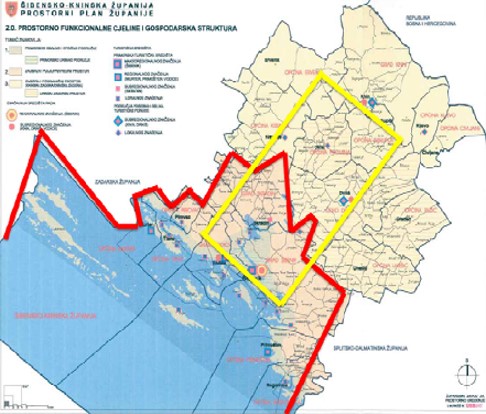
Map of the coastal zone of the Šibenik-Knin County: administrative units and the territorial waters (red) and the ecosystem of the Krka River (yellow)
© Šibenik Knin County & PAP/RAC
Pictures
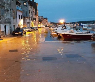
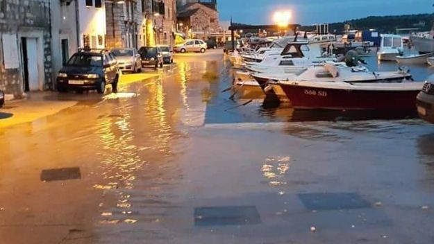
Flooded Šibenik waterfront in Dolac
© ŠibenikIN
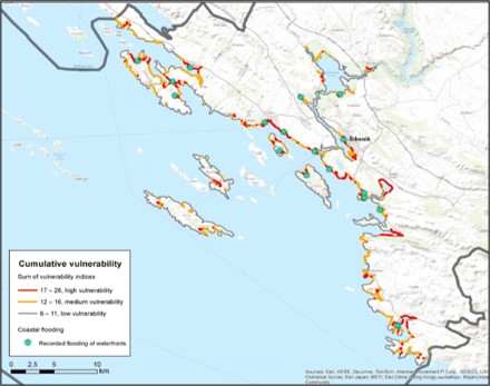
Cumulative vulnerability and coastal flooding from Coastal Plan Map collection
© PAP/RAC
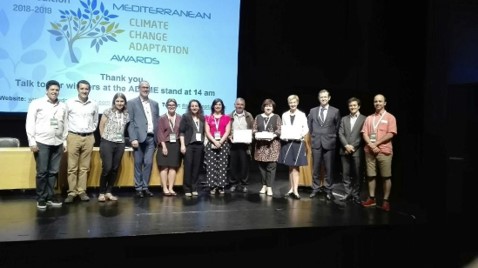
Šibenik-Knin Coastal Plan representatives receive Medadapt Award
© Damir Matešić
Documents
https://iczmplatform.org/storage/documents/pEoju2FqfXjzPoYBLsKZiD3o6ONBXxJ44RTWFt7P.pdf