Integrated system for the protection of Venice and its lagoon against flooding
Geographic context and climate challenges
Located along the northernmost stretch of the Italian Adriatic coast, the Venice lagoon is a large (550 km2) shallow water (average depth around 1 m) system connected with the sea through three inlets (from north to south Lido, Malamocco and Chioggia). Two main urban areas are located within the lagoon: the historical city of Venice, in the middle of the lagoon, and the town of Chioggia at its southern end. Smaller settlements are spread over other lagoon islands (e.g. Burano and Murano) and along the littorals (the two barrier islands of Lido and Pellestrina and the littorals of Cavallino and Sottomarina connected to the mainland) that separate the lagoon from the sea. The lagoon hosts diverse habitats, including 40 km2 of salt marshes (i.e. low-lying areas covered with halophytic vegetation), tidal flat shoals, subtidal flats and a 1,500 km network of canals. This articulated morphological system shapes the propagation of the tidal currents through the lagoon and provides habitats for a rich biodiversity.
The movement of water inside the lagoon is governed by the semi-diurnal tide, with a range up to 1 m; this is the highest in all of the Mediterranean Sea. Low pressures and strong winds blowing over the Adriatic (in particular Scirocco wind from south-east) result in storm surges causing flooding (in particular if storm surges occur in combination with peak astronomical tides) of the city of Venice and of the other lagoon urban settlements.
During the twentieth century, the city of Venice and the entire lagoon have become more and more exposed to flooding, due to the combined effect of:
- Subsidence: currently about 1 mm/year for the historical centre of Venice and up to 3-4 mm/year in the northern basin of the lagoon (Tosi et al., 2018). During 1950-1970, the city lost about 12 cm due to human induced subsidence, caused by groundwater withdrawal for industrial purposes, which was stopped after the 1970s.
- Eustacy: about 8-10 cm from the 1970s to present day.
- The progressive erosion and alteration of the typical lagoon morphologies.
The combined effect of eustacy and subsidence led to an increase of the relative mean sea level that is currently about 31 cm (average of the last 15 years) higher than it was in 1897. Consequently, the ten-year distribution of exceptional high water events (defined as tidal event reaching at least the level of +110cm above the local zero) shows a sharp increase starting from the second half of the 20th century: from 13 events in the decade 1950-59, to 44 events in 1990-1999, up to 95 events in the decade 2010-2019 (more data on these aspects are available on the website of Tidal Forecasting and Early Warning Centre of the Venice Municipality, ICPSM website).
Different areas of the city of Venice are characterised by different ground elevations with respect to the local tidal level zero. The lowest point of the city (+64 cm) is located in front of San Marco church and the entire San Marco square is characterised by low elevation (about +80/+90 cm). A tidal event of +110 cm causes flooding of about 12% of the city of Venice, while 70% is flooded in case of an event of +150 cm and 88% when the high water level reaches +190 cm (ICPSM website).
The most severe flooding event ever registered occurred on the 4th of November of 1966 when the water reached the record level of +194 cm and remained above +110 cm for 22 hours. After that event, the entire world became aware of Venice’s high vulnerability, leading the Italian State to issue special laws for its safeguarding. Therefore, studies and projects began to secure Venice from flooding, leading in 1981 to a first preliminary project, which for the first time included the idea of creating mobile construction at the three sea inlets. After a prolonged phase of detailed studies, planning and designs, this solution was brought to an implementation phase only in 2003. The year 2019 will long be remembered for the extraordinary number of exceptional whether-marine events and related floods that took place between November and December: on the 12th of November the water reached the remarkable level of +187 cm (the second highest ever registered), while in the same week the tide exceeded +140 cm other three times. The images and videos of the storm surge hitting the city on the night of the 12th of November were diffused all over the world and contributed in breaking a deadlock in the protection work of the city.
Sea level rise induced by climate change is expected to further worsen the risk of flooding. According to Antonioli et al (2017), relative sea level rise projected by 2100 for the North Adriatic (area in front of Venice) ranges from 58 to 101 cm. Such estimates include the contribution of local vertical movements (land tectonic and glacio-isostatic rates) and global eustacy projections (according to the most severe IPCC AR5 RCP 8.5 scenario). Conversely, a decreasing trend of storminess over the Adriatic basin has been projected by several models in moderate to severe emission scenarios (Bonaldo et al., 2017; Lionello et al., 2017), though high uncertainties characterise these projections, that should be taken with care. In absence of protection measures, sea level rise will not only directly affect the number and intensity of flooding events, but will also have other implications. It will further increase the lagoon water depth, which has grown over time in particular due to the erosion of the typical lagoon natural habitats, and will likely increase the erosion and loss of tidal flat shoals and salt-marshes. Sea level rise is also expected to expose the littorals to increased erosion and flooding, threatening their protection function for the entire lagoon as well as posing the littoral settlements and communities at a greater risk.
Objectives
To protect the city of Venice and its lagoon from flooding an integrated system of interventions is being implemented. This is part of an even wider framework defined by the so-called “General Plan of Interventions” firstly established in 1986 in accordance with the special legislation for the safeguard of Venice. The general plan includes three interrelated major objectives: defence of the city from high water events, defence of the littoral and the lagoon from sea storms and environmental protection of the lagoon.
Adaptation measures implemented in the case
Adaptation or improvement of dikes and dams
Beach nourishment
Dune construction and strengthening
Raising/expanding coastal land
Restoration and management of coastal wetlands
Solutions
The integrated system for the protection of Venice and its lagoon from flooding is formed by three major blocks of interventions: mobile barriers at the three lagoon inlets, local measures for the defence of urban areas, and protection of the lagoon littorals.
The mobile barriers, commonly known as the MOSE system, consist of rows of flap-gates installed at each of the inlet channels. The barrier at Malamocco inlet is formed by 19 gates and that of Chioggia by 18 gates. Due to its width and the presence of two channels (Treporti on the north and San Nicolò on the south), the Lido inlet hosts two barriers, respectively formed by 21 and 20 mobile gates. In normal tidal conditions, the gates rest on the bed of the channel (within caissons placed on the bottom), completely invisible and without affecting water exchanges between the sea and lagoon. When a tide exceeding a defined safeguarding level is forecasted, compressed air is injected into the flap-gates expelling water from their interior, making them float, rotating around their hinges and forming a barrier that emerges from the inlet bottom. In this way, the lagoon is temporarily isolated from the sea and blocks the tide from entering the lagoon. The inlets remain closed for the duration of the high water event and the due logistic operations. Afterwards, the gates are filled with water and return to their original position within the caissons. The gate closure-opening manoeuvres follow precise procedures and are based on a decision support model. In case of exceptional high water events, gates are closed maintaining sufficient freeboard during closure for possible increase of water in the lagoon due to input from rivers, input from rain and water passing between one gate and the next (all these inputs are very limited in volumes) as well as local water set-up due to winds blowing over the lagoon (i.e. Bora wind blowing from north east tends to push water towards the south-western area of the lagoon where Chioggia is located, increasing its flooding risk).
The mobile barriers are mostly complete (more than 95%). Although some works on the barrier’s service systems must still be finalised, MOSE has been utilized, even if still in a test phase, several times during autumn 2020, protecting the city of Venice and the lagoon from severe high tide events. When MOSE is fully operational, it will be activated when the tide reaches the +110 cm threshold. This implies that tidal events between +80 cm (the elevation of the lowest area in Venice corresponding to San Marco square) and +110 cm will still cause flooding in some parts of the city.
For this reason, mobile barriers are integrated with local defence measures, mainly consisting in raising the elevation of the embankments and urban pavements in lower areas (possibly up to +110 cm) of urban settlements located in the lagoon and in the littorals. Other local defence measures (as small gates along urban canals and protecting walls) are implemented in some areas where it is not possible to raise the elevation of the urban pavement. These interventions have been completed in several public areas, but not in all of them, and do not concern private urban spaces. 12% of the city of Venice is still flooded when the tide reaches the +110 cm level and the mobile barriers are not activated. Due to its particularly low elevation, San Marco square represents the most critical area of the entire city of Venice: a +90 cm tide floods almost 2/3 of the square, which is completely submerged with an event of +100 cm. In this area, only few local defense measures have been implemented for the moment, in particular to protect the narthex of San Marco church up to about +88 cm. A much wider and articulated design to protect the entire square and the surrounding area in up to +110 cm events has been conceived (including the elevation of low-lying embankments and urban pavements as well as on the reorganisation of the entire sewage and drainage system) which will be implemented in the next years.
Protection of littorals from storm surges and erosion represents the third pillar of the complex of intervention aiming at safeguarding Venice and its lagoon from flooding. The 60 km littoral strips (from north to south Cavallino, Lido, Pellestrina and Sottomarina) were reinforced through an extensive beach nourishment intervention using about 9 million cubic meters of sand. This was integrated with grey measures, including the strengthening of ancient defence systems (the so called “murazzi”, seawalls made of stone blocks along part of the Lido and Pellestrina islands placed behind the sandy beach), the reinforcement of existing groynes and of the six jetties delimitating the lagoon inlets and the construction of submerged reefs in front of the nourished beach for wave dissipation. Finally, 8 km of dunes were strengthened or reconstructed, in particular along the Cavallino littoral, with the dual goal of providing greater coastal protection and re-establishing precious coastal habitats. The described interventions on the lagoon littorals have all been completed and are regularly monitored and maintained.
In response to the infringement procedure set by the European Commission in 2003 due to conflicts generated by the construction of the MOSE system with the Natura 2000 Directives, a Plan of environmental measures has been developed, aiming not only at providing compensation but more in general at restoring and requalifying the lagoon ecosystem. The plan includes several typologies of measures, such as the reconstruction of salt marshes and tidal flat shoals, the transplantation of seagrass to form new meadows, the creation of new littoral habitats (e.g. dunes), the environmental requalification of the construction sites of the MOSE system at the three inlets and other interventions aiming at improving the environmental value of the lagoon Sites of Community Importance (SCI) and Special Protection Areas (SPA). This ambitious plan has been only partially implemented and will have to be completed in the next years, in close coordination with all the interventions aiming at counteracting erosion, a still unsolved, critical problem affecting the Venice lagoon.
Leader of the initiative and key partners
The National Ministry of Infrastructure and Public Works, through the Interregional Superintendence for Public Works of Veneto, Friuli Venezia Giulia and Trentino Alto Adige (the former Venice Water Authority) is responsible for the physical and environmental protection of Venice and its lagoon, therefore including its protection from flooding. Through its concessionary, the Venezia Nuova Consortium, this body carries out all the activities envisaged by the “General Plan of Interventions”. The implementation of this plan is supervised by the Joint Steering, Coordination and Control Committee pursuant to Law 798/84, where competent national (different Ministries) and local institutions (Veneto region and various municipalities, including that of Venice) are represented. Local defence measures have been implemented both by the former Venice Water Authority, through its concessionary, and the municipality of Venice, through Insula spa, the operational company of the municipality for urban maintenance and infrastructures.
Article 95 of the national law 126 of the 20th of October 2020 converted in law a previous decree, which established the “Authority for the Venice lagoon”. This new body will absorb the competences of the former Venice Water Authority on the safeguard of Venice and its lagoon, and will be responsible for the management and ordinary maintenance of the MOSE system.
Stakeholder participation
Since its conception, the MOSE project encountered strong local opposition, which has continued during the years. In general, opponents complained about weak stakeholder engagement and a lack of full transparency in the decision making process. Major concerns raised by opponents are related to the lack of a full assessment of alternatives, the excessively high costs of the barriers, damages caused by the construction phase, alteration of the lagoon ecosystem and its hydrodynamics and morphology and risk of failure of the system in case of particularly harsh conditions.
In any case, it shall be considered that the MOSE project was based on precise design constraints, defined by specific legislative and governmental acts. It was also subjected to a long and in-depth technical and administrative approval process that involved several organisations and authorities. Input gathered during this process have been used to update and review the technical solutions of the project.In 2018 a public debate with interested local stakeholders was launched to discuss how to better integrate the mobile barrier systems within the lagoon environment and the three inlets in particular, focussing on landscape and architecture aspects (more information on this process is available through a dedicated website).
Success and limiting factors
The history of MOSE is long and complex, making an evaluation of success and limiting factors a challenging exercise. Indeed, it is simply impossible to give evidence of the whole spectrum of different (negative and positive) considerations on such a huge intervention expressed by proposers, supporters and opponents.
The planning and design phase of the mobile gates began in the eighties of the last century, while their construction started in 2003. The entire process has been hindered by various factors, including lack of full stakeholder engagement and related strong local opposition, ramping of costs and an overall delay due to technical and management problems, including those related to financial availability and institutional conflicts. Moreover, in 2013-2014 investigations revealed a vast system of corruption that led to the arrest of politicians and business managers involved in the project. As a consequence, the works were temporarily stopped and the completion date was further delayed.
The dramatic flooding event on the 12th of November 2019 revealed again the fragility of Venice and of the other historical lagoon settlements and reaffirmed the need to proceed as quickly as possible with the implementation of the system. After several tests, MOSE was firstly and successfully operated on the 3rd of October 2020 protecting Venice from a +130 cm high tide event. Afterwards, between October and November 2020 the mobile barriers have been closed several times and proved to be effective in protecting Venice under different conditions, including particularly harsh ones such those with strong Scirocco and Bora winds, repeated closures and prolonged closures (due to 4 consecutive +120-130 cm high water events, between the 4th and the 6th of December the mobile gates remained closed for about 45 hours, with just a temporary reopening of the Malamocco inlet for about 3 hours on the 5th of December 2020).
The MOSE system is part of a wider system of interventions. Actually, the integration of different typologies of measures (mobile barriers, local urban defences and defence of the lagoon littorals) contributing to the same objective is one of the major strengths of the approach used to protect Venice and its lagoon. As described in the section about “Solutions”. Some pieces of the system must still be completed and there are other elements to work on:
- The procedure for the closure of the mobile barriers is activated when a defined safeguarding level is forecasted. Currently, different forecasting systems are available, including that operated by the Venezia Nuova Consortium and the one managed by the Tidal Forecasting and Early Warning Centre of the Venice Municipality, which also provides early warnings on approaching high water events to the population. Much has been done to improve the reliability of the forecasting models; however the uncertainty of the forecasts remains an important issue.
- When the mobile gates are closed, any shipping activity through the inlets is blocked, thus affecting the normal operation of the Venice port (which is situated inside the lagoon of Venice) and other navigation-dependent activities, in particular fisheries. A navigation lock at the Malamocco inlet has been constructed to ensure the operational continuity and access to the Venice port for commercial ships even when the mobile barriers are raised. Moreover, refuge havens and small navigation locks, at the Lido and Chioggia inlets, have been constructed to enable pleasure boats and emergency vessels to take shelter and pass through the inlet while the barriers are in operation. These lock and refuge systems are still not in operation.
- From an engineering perspective, the technical life of the MOSE system has been estimated at 100 years. However, its operative life depends on the rate of future sea level rise. This will affect the frequency and number of closures. At certain levels of sea level rise, the frequency of closures might become unmanageable and unsustainable, due to the consequent effects on the lagoon ecosystem and the port operation. This issue is the objective of recent and still on-going studies: e.g. according to Umgiesser, (2020) a sea level rise of 50 cm will cause the barriers to be closed on average once a day, while with a sea level rise of 75 cm the lagoon will be on average more hours closed than open. Indeed, it shall be noted that this problem is not specific for the MOSE project, but it would have affected any alternative solution aiming to regulate tidal fluxes at the lagoon inlets to protect Venice.
Costs and benefits
The total cost of the mobile barriers is estimated at 5.5 billion Euro, also including the requalification of the facilities of the Venice Arsenal for the maintenance and operation of the MOSE system, and the requalification works needed to improve the integration of the mobile barriers within the lagoon environment. Funding sources have been provided at the national level by the Italian State, which will also provide resources needed for the operation and maintenance of the system. Official estimations of maintenance and operation costs are not available yet.
The main positive outcome is the protection of Venice and its lagoon from flooding due to tide and storm surges, including extreme events, in present day and – to a certain extent – future sea level conditions. This has evident socio-economic benefits, since it will avoid damages to socio-economic activities of the lagoon urban settlements due to flooding. Moreover, mobile barriers could be potentially operated to contribute to the environmental restoration of the lagoon by regulating, in specific conditions, the tidal flow inside the lagoon and the water exchange with the sea; e.g. increasing tidal flushing and water renewal in lagoon areas prone to summer anoxic crises.
Implementation time
Following the special laws issued at the national level from 1973 that declared the safeguarding of Venice and its lagoon “a problem of pre-eminent national interest”, the planning phase of the MOSE system started in the 1980s and was a lengthy process. The first projects were drafted in 1981, 1989 and in 1992, receiving the approvals of the Superior Council for Public Works. In the same period, to support planning and select the best solution among possible alternatives, several studies about the environmental state (hydrodynamics, morphology, meteo-marine conditions, and water quality) of the Venice lagoon were performed. Full scale experimental trials were even implemented and remained in place from 1988 to 1992. After the definitive project was approved in 2002, works for the construction of the MOSE system finally started in 2003. In July 2020 the first complete test with all mobile barriers was executed with success. The works have been completed for more than 95% and the system is expected to fully come into operation in 2021. In the meanwhile, the mobile barriers were already used in autumn 2020 to protect Venice from high water events. Local defense measures have been completed in several areas of the lagoon settlements. However, works to ensure the protection of 12% of the public area of the city of Venice, including the area of San Marco square, up to the safeguarding level of +110 cm must still be completed. Major protection interventions along the littorals have been completed, while regular and extraordinary maintenance is on-going. From an engineering perspective, the technical life of the MOSE system has been estimated at 100 years. However, its operative life depends on the rate of future sea level rise.
Contacts
Elena Zambaldi
Consorzio Venezia Nuova
Castello 2737/F, 30122 Venezia
E-mail: elena.zambardi@consorziovenezianuova.com
General e-mail: info@consorziovenezianuova.com
Source for more detailed information
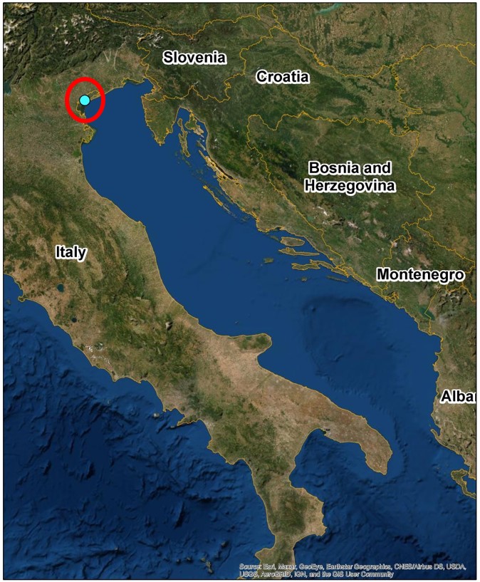
Map
Pictures

Title: Historical series of exceptional high water events in Venice
Description: Change in the mean sea level in Venice and the yearly distribution of exceptional high water events (tidal events higher than +110cm above the local zero)
Source: Tidal Forecasting and Early Warning Centre of the Venice Municipality; https://www.comune.venezia.it/it/content/variazioni-livello-medio-mare
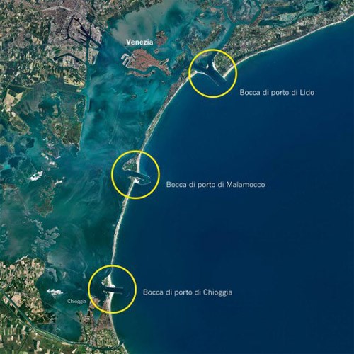
Title: The Venice lagoon and the three inlets
Description: The Venice lagoon communicates with the sea through three inlets; form north to south: Lido, Malamocco and ChioggiaSource: https://www.mosevenezia.eu/
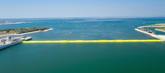
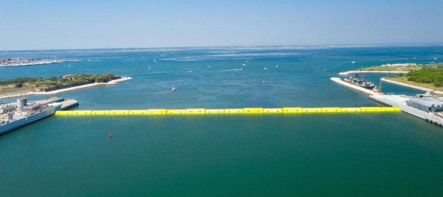
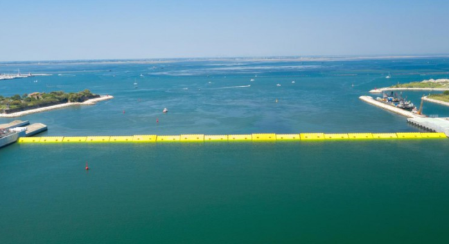
Title: The mobile barriers of the MOSE system
Description The first complete test was executed with success in July 2020
Source: https://www.mosevenezia.eu/
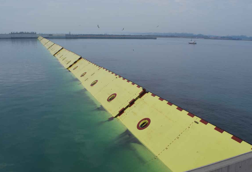
Title: Flap-gates
Description: Details of the flap-gates installed at San Nicolò during an operation test
Source: https://www.mosevenezia.eu/
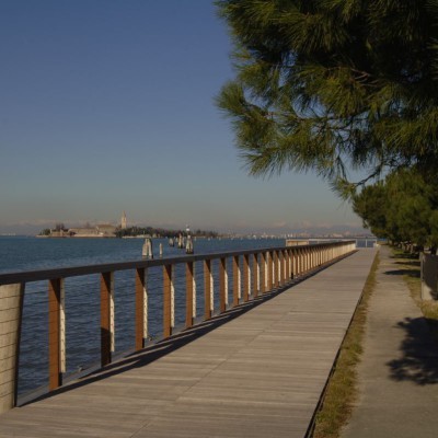
Title: Local defences at Malamocco village on the Lido littoral
Description: Local interventions aiming at raising and strengthening the embankments along the lagoon are complementary measure to the MOSE system and part of the same integrated approach.
Source: https://www.mosevenezia.eu/
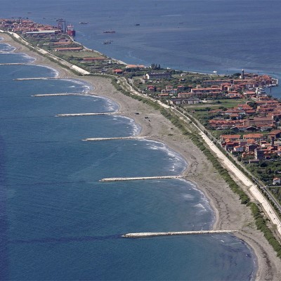
Title: Beach nourishment along the Pellestrina littoral
Description: A large programme of beach nourishment was implemented to protect the Venice littorals from storm surges, including the one that led to the creation of the Pellestrina beach in front of the ancient “murazzo” (seawalls) defence system. Beach nourishment was integrated with groynes and submerged reefs.
Source: https://www.mosevenezia.eu/
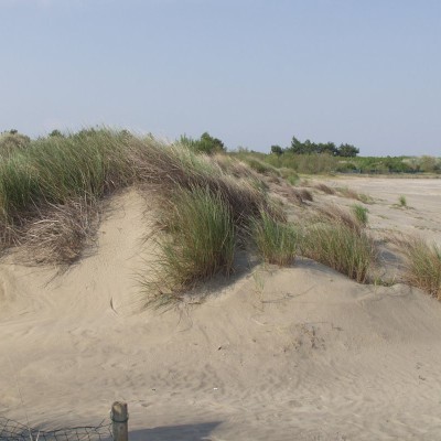
Title: Dune habitats at Cavallino littoral
Description: At Cavallino littoral, beach nourishment was integrated with dune strengthening and re-vegetation to offer natural defence against sea erosion.
Source: https://www.mosevenezia.eu/