Managed retreat of the coastal state road Koper-Izola and sustainable requalification of the coast
GEOGRAPHIC CONTEXT AND CLIMATE CHALLENGES
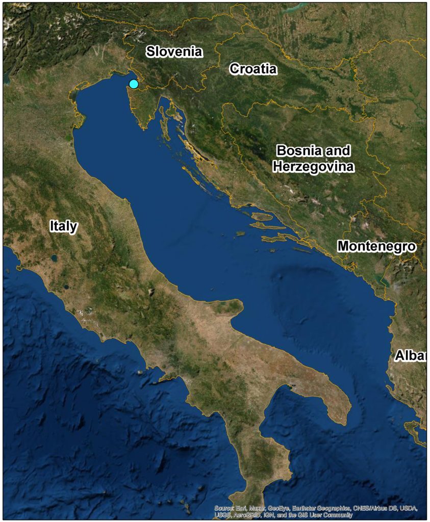
The Coastal-Karst Region is the only Slovenian littoral region, as well as being a characteristically border region, as it borders with both Croatia and Italy.
Koper is the urban regional centre, while also being the main city of the wider Coastal conurbation (along with Izola and Piran). The city is the economic, administrative, cultural, educational, and employment centre of the region. Moreover, the city is also a logistic and traffic nexus of international importance, with a developed cargo and a developing passenger ports.
Izola is a lower-rank urban centre, with a developed touristic centre and provides basic services on the primary level, as well as some state administration services.
The traffic between the cities of the urban conurbation is based on roads. A state road hugging the coast for its entire length of about 5 km, linked the cities of Koper and Izola. The road occupied the coast under high flysch cliffs and thus degraded an attractive landscape, destroyed coastal and endangered marine habitats (e.g. the meadow of Posidonia oceanica), used the space attractive for recreation between the urban centres. Furthermore, it was subject to deleterious impacts of the high sea levels and strong waves.
Due to increasing traffic, the old road did not even comply with traffic regulations. The demands for decongestion of the coast and changes of its use into recreational and green area were becoming louder and louder. Such a change would also serve a high level of nature conservation and improvement of the landscape quality.
Recently, an additional question of ensuring traffic safety along the coast was raised, which is endangered by climate change impacts (increasing sea levels and flood risk in extreme weather conditions, which are becoming more common).
The models of climate change in Slovenia show significant increase in the average air temperature by the end of the 21st century across Slovenia and in all seasons. The extent of increase is dependent on the GHG emissions scenario. The optimistic scenario forecasts by 2100 an average temperature increase of 1.3 °C over the average for the 1981-2010 period, the moderately optimistic scenario expects an increase of 2°C, while the pessimistic scenario expects the raise of about 4.1 °C.
IPCC’s SROCC report from 2019 forecasts by 2100 the mean sea level rise of 29 cm according to the most optimistic scenario up to 1.1m according to the worst-case scenario (IPCC, 2019).
As stated by Ličer (Ličer, M: s.d.), the sea surface increase in Koper between 1961 and 1995 did not present a statistically significant trend, but the increasing trend has started in the 90s. After 1995, the statistically significant mean increase in sea level is about 5 mm/annum.
Since 1961, the sea level has exceeded 330 cm for 55 h and 350 cm for 8 h above the tidal gauge zero. Knowing that Koper tidal gauge zero is 218 cm below the mean sea level, it can be said that since 1961, the sea level exceeded 112 cm for 55 h (amber alert level), and 132 cm for 8 h (red alert level) above the mean sea level. Over this period, 6 red alert events occurred.
The Northern Adriatic models are largely unanimous in claiming that the sea level will rise by at least about 30 cm by 2100. Consequently, this will mean that the amber alert threshold will be exceeded for at least 1153 h, while the red alert threshold will be exceeded for at least 149 h, which is a 20-times increase in the cumulative time of flooding in the amber and red alerts zone. According to the IPCC “SROCC” report from 2019 (IPCC 2019), the sea-level rise of 29 cm by 2100 would represent the lowest range of the most optimistic scenario (RCP2.6.). In the worst-case scenario, the sea level will rise by 1 meter. In this case, the cumulative time of flooding above the amber and red alerts would be 3300-times longer than that in the period 1961-2017 (Ličer, s.d.).
OBJECTIVES
The project of construction of a new road connection removed from coast follows the goals:
● Ensure a modern road connection between the cities of Koper and Izola, as part of the state express road Koper (Slavček)-Lucija,
● Rearrangement of the degraded coastal area into an attractive, green, recreational area, coordinated with the wider scheme of the network of nature protected areas (Škocjanski zatok Nature Reserve, Landscape park Strunjan),
● Ensure close-to-nature arrangements, which will be resistant to the expected climate changes in the future.
ADAPTATION MEASURES IMPLEMENTED IN THE CASE
Managed retreat
SOLUTIONS
The project implementation is divided into several phases. The first phase included preparation activities, confirmation of the location plan, preparation of project documentation, as well as the construction of the section of the express road Koper (Slavček) – Izola, including a tunnel. The second phase focussed on minimal, temporary arrangements of the coastal road area between Koper and Izola, which enabled recreational use of the space after the withdrawal of traffic. The third implementation phase is currently ongoing and involves the preparation of the needed spatial and project documentation, which will be followed by the final implementation of a close-to-nature arrangement of the coast of the former state road between Koper and Izola.
Even the initial investor into the modernisation of the coastal road between Koper and Izola (Republic Road Administration) in the early 90’s was aware of the sensitivity of the possibility of constructing a road section between Koper and Izola. A number of solutions of the route trajectory were discussed: along the coast, partly along the coast, and a tunnel between Koper (Slavček) and Izola. The investor implemented an urbanistic/landscape tender to determine the trajectory of the coastal road and the arrangement of the meeting points. The options that withdrew the road (partly or fully) into the tunnel received the best reviews. This decision of the tender commission demonstrates the awakening of the environmental consciousness and sensitivity to the spatial quality of the coast, as a predecessor of the consciousness of the urgency of climate change adaptations.
The plan for the new road was confirmed in 2004. The road construction commenced in 2006, while the tunnel construction started in 2010. After numerous issues and complications, the tunnel was opened to traffic in 2015.
In the second phase, both municipalities arranged a biking lane, toilets, and equipped the space with small equipment (benches). The Municipality of Koper also arranged access to the sea and public lightning. Ahead of that, both municipalities negotiated with the Ministry of Infrastructure that the tunnel be exempt from the vignette system, and that the management of the coastal road be given over to the two municipalities. This established the conditions which entirely eliminated car traffic on the old coastal road, enabled the arrangement and wide recreational use of the former road space.
In the third phase, the spatial plan (Regional Spatial Plan) for a comprehensive arrangement of the coastal belt as a public space with a clearly emphasised common vision of spatial planning, based on sustainable development, is under preparation. This demands careful coordination of the projects for recreational infrastructure, tourism development projects, as well as projects dealing with nature conservation, sustainable mobility, urban renovations, etc. All of the approaches will be integrated with the principles of sustainable development, within the framework of a coordinated comprehensive management. The main elements of the spatial arrangement in the document are the coastal promenade with established access points to the sea, piers, and the raising of the area to adapt to the climate changes, alongside a touristic-cultural valorisation of the area, with a shipwreck presenting a tourist attraction.
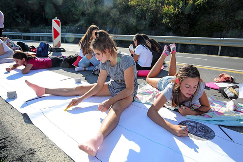
Numerous workshops and tenders, dealing with arrangement of the coastal space between Koper and Izola were carried out in the past two decades. These resulted in a rich and expansive documentation which will allow the formulation of ideas for future arrangements. The initiative “Narišimo obalo” (Let’s draw the coast) was very successful, as it involved a wide range of participants in active co-creation of the vision of the space.
The campaign was carried out under the leadership of the NGO “PINA”, and was attended by around 1,000 people, mostly youngsters.
Foto: Natalija Gajić, info@pina.si
https://ipop.si/2019/10/14/partnersko-urejanje-prostora-v-mariboru-in-na-obali/
The decision to remove the road into a tunnel has in recent times been recognised as beneficial from both viewpoints: adaptation and mitigation. This road retreat reduces the vulnerability of this important traffic artery to climate change impacts, in particular to the expected sea-level rises and more frequent extreme weather conditions including the corresponding coastal erosion risk.
As for mitigation, the tunnel shortened the distance between Koper and Izola by approx. 900 m. With an average daily traffic through the tunnel of 35,000 vehicles, this means significantly lower CO2 emissions. Assuming an average fuel consumption of 6.5 l / 100 km and a 1:1 ratio of vehicles with a petrol and diesel engine, this means around 1,900 t less CO2 emissions in one year.
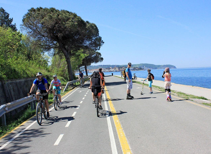
The coastal road has become an attractive recreational area, which is very popular and well visited, especially during weekends
Foto: Nace Novak, info@primorske.si
https://www.primorske.si/2018/04/26/nenalicena-kolesarska-lepotica
LEADER OF THE INITIATIVE AND KEY PARTNERS
In the first phase, associated with the road construction, the initiator was the Ministry of Infrastructure together with the Ministry of the Environment and Spatial Planning, and DARS (Motorways Company in the Republic of Slovenia) in the construction phase. After the construction of the road section (including the tunnel), the issues of temporary and long-term arrangement of the coast came to the forefront. The initiative was then taken over by the Municipalities of Koper and Izola. Both municipalities negotiated with the Ministry of Infrastructure and achieved that the old coastal road was re-categorised (and entirely closed to traffic), which necessitated the exemption of the new road section Koper (Semedela)-Izola from the vignette system enabling thus free passage for all vehicles. This presented the foundation for the implementation of a minimal arrangement (public lightning, access to the sea, public toilets, small urban equipment, designation of bike lanes, etc.). Going forward, the two municipalities are preparing together special spatial and technical documentation for a comprehensive arrangement. They have authorised the Public Institute for Entrepreneurship (Municipality of Izola) to carry out this work. This institution thus took over the operational coordination of activities in the name of the initiators (Municipality of Koper and Municipality of Izola), needed for the final arrangement of the coast. In the framework of preparation of the programme concept for the area this Institute worked with the NGO PiNA on the initiative “Narišimo obalo”, which attracted about 1,000 participants.
STAKEHOLDER PARTICIPATION
In the first phase stakeholders collaborated intensively in the framework of the Spatial Planning Act, during regular coordination meetings, public consultations and presentations.
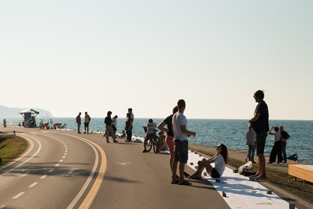
The Public institute for Entrepreneurship successfully collaborates with a wide range of stakeholders. In the scope of those activities, the PiNA association implemented an action of participatory community spatial planning in the region – NARIŠIMO OBALO (Let’s draw the coast) in September 2018. The initiative was supported by the Municipality of Izola – Facility point for the implementation of the European Union Strategy for Adriatic-Ionian Region (EUSAIR), some ministries, the European Social Fund, and Interreg V-B Adrion. The action took place within the Week of the Mediterranean Coast (related to Mediterranean Coast Day) and Macro-regional Strategies.
This whole-day event took place in the area of the coastal road between Koper and Izola. Participants of different profiles and age groups made suggestions about what the future use and look of the area of the disused coastal road should be like. The participants filled 750 m long paper band with their ideas. More than a 1,000 people from all across Slovenia and some other European countries participated. Young people, member of the civil society, as well as primary and secondary school students were particularly well represented. All suggestions were studied and integrated into a written analysis by the colleagues at the PiNA association. They also produced video materials of the event. The produced material is a valuable contribution for the preparation of the Regional Spatial Plan.
Participants expressed their views on the future coastal arrangements and use. The results were elaborated and publicly presented.
Foto: Tomaž Primožič/FPA info@primorske.si
https://www.primorske.si/primorska/istra/analiza-predlogov-za-obalno-cesto-zelijo-rekreacij
FPA, FOTOGRAFSKE STORITVE, TOMAŽ PRIMOŽIČ, S.P. (Fotografske storitve in oprema, Ulica Sergeja Mašere 1, 6000 Koper – Capodistria) Tel. 041 622 578
SUCCESS AND LIMITING FACTORS
The success factors of the described project are mainly in the maturity of the political actors on both national and local levels. This enabled the decision that, despite the high costs, a new 2.2 km long tunnel would be built allowing thus for the removal of the road from the coast. This in turn allowed an arrangement which is, on one hand, less sensitive to the expected climate change impacts, while on the other hand, the local actors have given priority to the public use of the space over private, commercial interests, which allows for sustainable development solutions.
A comprehensive approach to the management of the area is important. This approach successfully integrates interests of various sectors and actors in the framework of integrated management (particularly in the protection of the natural and cultural heritage). Extending beyond municipal boundaries the inter-municipal cooperation in vision development and operational programme for future arrangement of the area are crucial. All the while, it is very important to establish a wide cooperation platform, including active involvement of the general public in the phases of vision development and determination of the future use of the space.
Experiences in the field of ICZM, which Slovenia gained within the framework of the Barcelona Convention (for example the CAMP Slovenia project with a two-year cycle of workshops for education of municipal and national planners on the inclusion of ICZM principles into practice), EU, and other international scopes (for example: cooperation in the EUSAIR – EU Strategy for Adriatic-Ionian region thematic pillar 3 – Environmental Quality, where ICZM and MSP-Marine Spatial Planning are key topics), were found to be important.
The phase of landscape planning is important for opening the space for meeting of expert and landscape solutions, with pronounced involvement of experts (e.g. Chamber for Architecture and Spatial Planning). This is particularly important to identify solutions that will also have to comply with the Article 8 of the Protocol on Integrated Coastal Zone Management. As it is an area directly and negatively affected by climate change and natural risks, this zone must remain, in principle, free from building.
Limiting factors can be giving in to formal and informal pressures from potential investors, which are aiming for partial solutions, which are damaging to comprehensive arrangements in the public interest.
COSTS AND BENEFITS
The construction of the express road section Koper-Izola required an investment of over 150 million EUR. The finances were provided by the state, in the framework of the National Programme for Motorway Construction.
The temporary arrangement of the road after its closure for traffic cost approx. 1 million EUR. The funds were provided by the Municipality of Koper (around 800,000 EUR) and the Municipality of Izola.
The exact estimate of the cost of the long-term arrangement of the former road is not possible in this phase, but it will be in a range of a few million EUR. The assessment of the investment, which was given in the completed feasibility study, is just under 5 million EUR and includes the preparation of the spatial and project documentation, arrangement of communal infrastructure (plumbing, sewerage, traffic arrangement, biking lane, public lightning), filling-in of the terrain, the arrangement of the promenade and bathing area, and the establishment of an underwater archaeological park in situ.
CONTACTS
Iztok Škerlič
JZP Izola (Javni zavod za spodbujanje podjetništva in razvojne projekte)
Izola, Sončno nabrežje 4
e: jzp@izola.si,
t: +386 5 66 00 260,
f: +386 5 64 01 052
SOURCE FOR MORE DETALIED INFORMATION
Regional spatial plan:
https://www.facebook.com/tvkoper/videos/prostorski-na%C4%8Drt-obalna-cesta/10155247605063008/
Last drive: https://www.youtube.com/watch?v=e1OQGgozWj4
Public event Draw the coast: https://www.youtube.com/watch?v=sMRy_hsZqMc
Report from the public event Draw the coast:
https://www.pina.si/wp-content/uploads/2020/02/NarisimoObalo.pdf
3B Arhitekti (Projektna skupina: Leon Belušič u.d.i.a., Damjan Hidič m.i.a.), Projekt Ureditev obale med Koprom in Izolo, 2018;
ClimatChangePost, https://www.climatechangepost.com/slovenia/coastal-erosion/;
Climate change projections for Slovenia over the 21 st century (Temperature and precipitation summary)
http://meteo.arso.gov.si/uploads/probase/www/climate/text/en/publications/OPS21_brosura_ENG.pdf
IPCC. 2019. Special Report on the Ocean and Cryosphere in a Changing Climate (SROCC). Edited by H.-O. Pörtner, D.C. Roberts, V. Masson-Delmotte, P. Zhai, M. Tignor, E. Poloczanska, K. Mintenbeck, et al. Geneva (CH): IPCC. https://www.ipcc.ch/srocc/.
Ličer, Matjaž. s.d. ‘Podnebne spremembe in naraščanje gladine morja v Severnem Jadranu’. Nacionalni inštitut za biologijo, Morska biološka postaja Piran. s.d. https://www.nib.si/mbp/sl/home/news/902-podnebne-spremembe-in-narascanje-gladine-morja-v-severnem-jadranu.
Ocena podnebnih sprememb v Sloveniji do konca 21. stoletja (Povzetek), http://meteo.arso.gov.si/uploads/probase/www/climate/text/sl/publications/OPS21_povzetek_posodobljeno.pdf
Primorske novice, https://www.primorske.si/2018/04/26/nenalicena-kolesarska-lepotica
Slovenian Environment Agency: Prognozirano plimovanje morja – Tide tables 2020, Jadransko morje – Koprski zaliv (Adriatic Sea – The Bay of Koper)
MAP
PICTURES

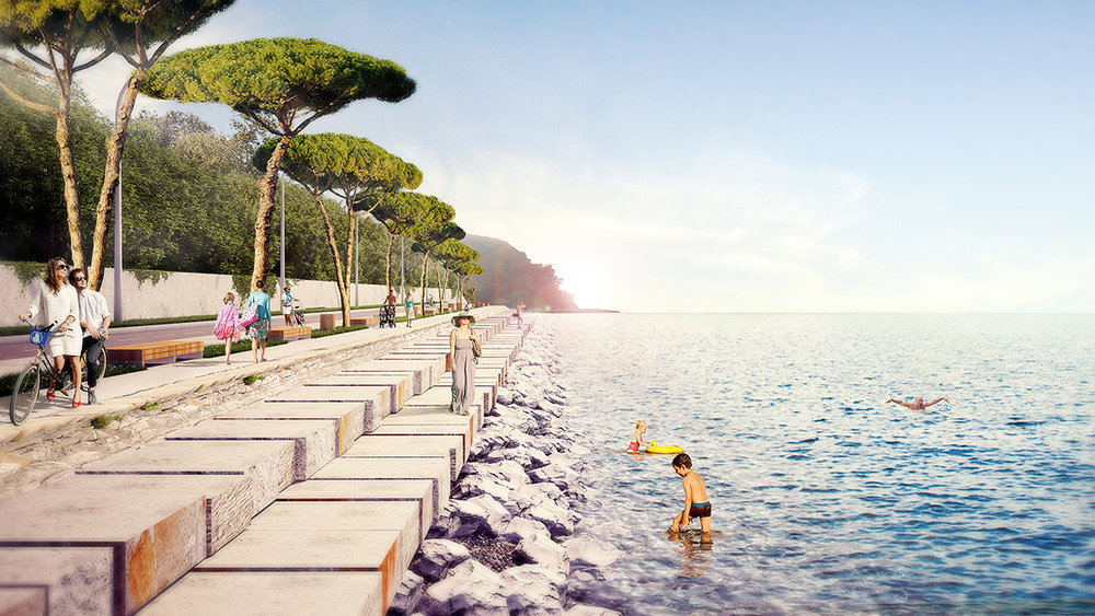
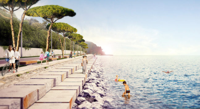
Special emphasis will be given to sustainable coastal protection, with comfortable and safe access to the sea
Authors: 3B Arhitekti, info@3b-arhitekti.si
https://www.google.com/search?q=obala+koper+izola+ureditev&tbm=isch&ved=2ahUKEwiJhPWB6qvpAhXYNOwKHZlDBycQ2-cCegQIABAA&oq=obala+koper+izola+ureditev&gs_lcp=CgNpbWcQAzoECCMQJ1COeViWjgFg9pEBaABwAHgAgAFfiAHgBZIBATmYAQCgAQGqAQtnd3Mtd2l6LWltZw&sclient=img&ei=TUe5XsmpGtjpsAeZh524Ag&bih=700&biw=1536&client=firefox-b#imgrc=wFKXdQ0bQxQYKM
DOCUMENTS
Report from the public event Draw the coast:
https://www.pina.si/wp-content/uploads/2020/02/NarisimoObalo.pdf