Restoration of the dune belt in the south of the Bevano river mouth (Lido di Classe, Ravenna, Italy)
Geographical context and climate challenges
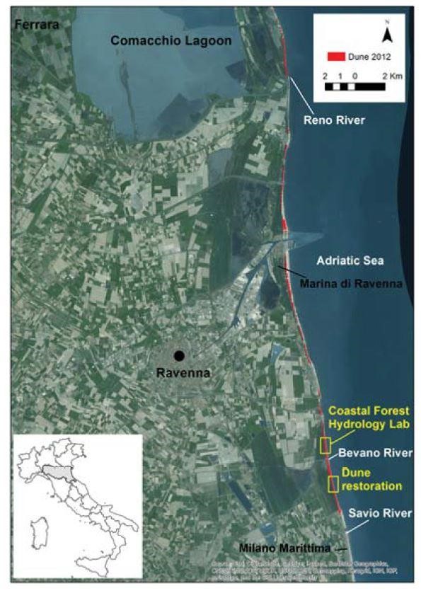
The site is located in the south of the Bevano river mouth, between an integral protected area, where access by unauthorized persons is forbidden all year round, and an intermediate protection zone, forbidden for access from April to July during the nesting period of the Kentish Plover (Charadrius alexandrinus). The anthropogenic pressure on this area is almost non-existent. The site is a Natura 2000 site, a protected area of the Po Delta Park; a SCI (Council Directive 92/43/EEC “Habitat” on the conservation of natural habitats and of wild fauna and flora. OJ, L206, 22/07/1992; pp. 7-50) and SPA area(Council Directive 79/409/EEC “Birds”on the conservation of wild birds. OJ, L103, 25/04/1979; pp. 1- 27); and a Ramsar area (UNESCO, 1971. Convention on Wetlands of International Importance Especially as Waterfowl Habitat).
The recently formed dune belt stretches laterally. In 2013 the dune had a variable height of 2-3.5 m, a vertical dune front, which is the evidence of erosion by storm surges, and a foot bordered by a belt of embryo dunes with partial recovery of the natural slope, which is the evidence of active and sudden deflation and wind accumulation.
The beach is about 30 m wide, with a sinuous longitudinal profile with wide and articulated intertidal zones. The beach stretch of interest is classified as “stable” according to the regional ASPE classification. The area is free from robust defence structures and has not been subjected to beach nourishment in the past. The area is classified as P3 in the storm surge hazard scenarios, i.e. subject to frequent flooding with a 10-year flood frequency. The subsidence rate in the area is about 7-8 mm/year.
The partial fragility of the dune system before the intervention was due both to the limited width of the beach, which is why embryo dune accumulations formed but did not resist the strongest sea surges, and to the cliff-like morphology of the front dune, which was constantly subjected to erosion.
Objectives
This intervention is a final activity within the project “Riged-Ra – Restoration and management of the Ravenna coastal dunes (2013-2016)”. The main objective of the project was to define and identify the main coastal dynamics, erosion status and vulnerability of the Ravenna coast, from the Reno to the Savio River mouths (Ravenna, Emilia-Romagna, Italy), and of the related dune remnants, by defining suitable intervention strategies for their protection and restoration. The final deliverable of the project included intervention strategies for coastal dune conservation in the form of Guidelines for local authorities who are directly involved in coastal zone management and planning.
The construction of the windbreak fence, on the other hand, aims to reduce wind speed so as to favour sand deposition; to favour the creation of embryo dunes; to prevent sand loss towards the hinterland; to prevent trampling; and to give an opportunity for ecosystem recovery.
Adaptation measures implemented in the case
Selection of one or more adaptation options from the AdriAdapt catalogue.
Dune construction and strengthening
Solutions
1) Identification and characterization of the area based on the integration of the data collected during the three years of the project implementation:
- geographical-environmental structure
- lithological and hydrogeological characterization
- geomorphological analysis of the dune-beach system
- study of the coastal vegetation succession
- climate and marine regime
- morphodynamic state of the beach
2) Selection of the most suitable nature-based solution intervention: windbreaks fence (ganivelle)
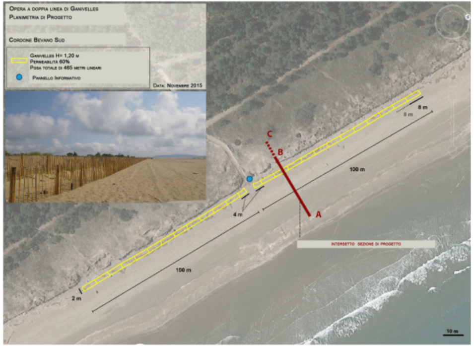
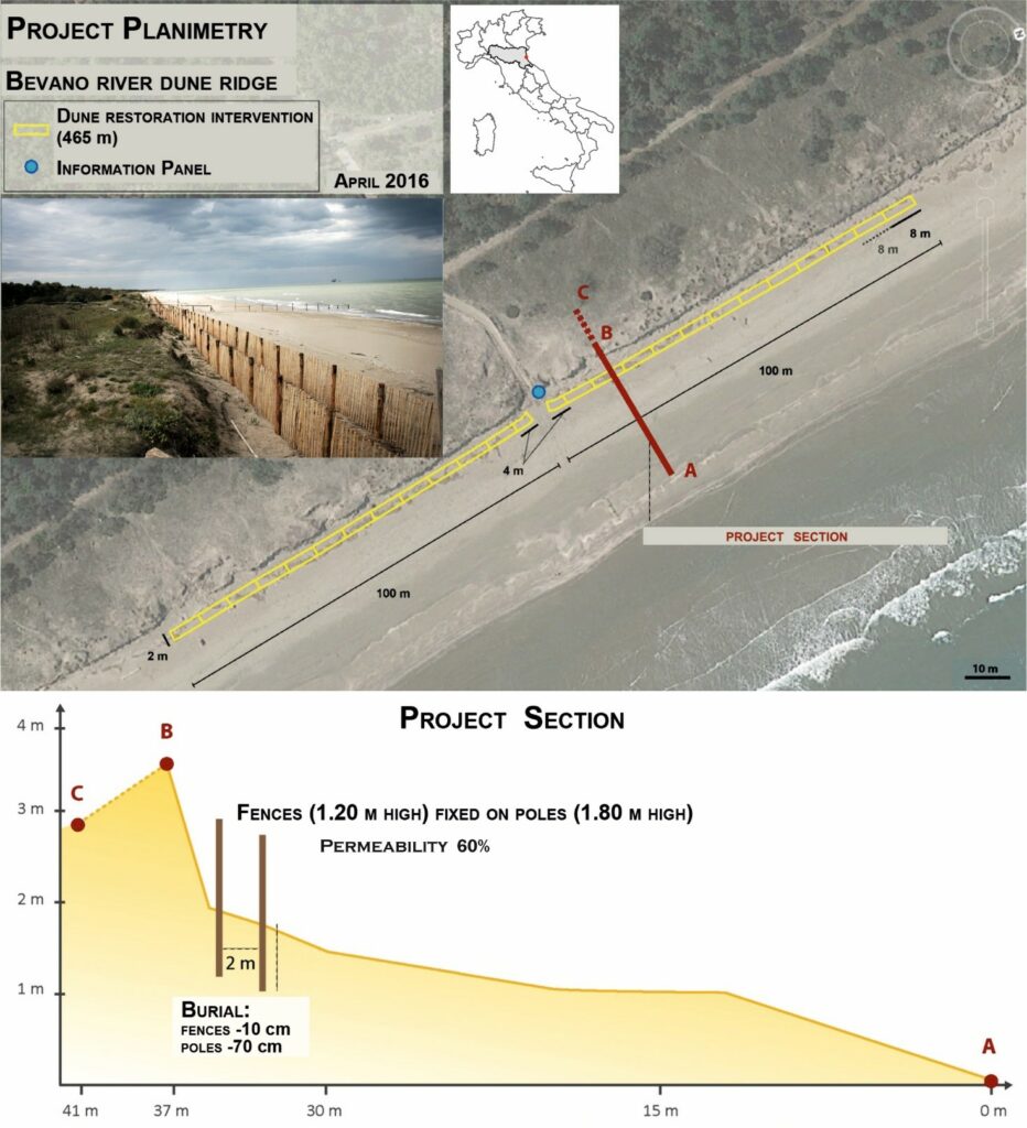
Project: Installation of a grid of windbreak fences (ganivelle) parallel to the coast, held together by galvanized and twisted iron wire. The first line was positioned at the dune foot; the second line is about 2 m from the first line towards the sea; the two lines are connected by perpendicular portions, every 8 m (‘mesh’ technique). The intervention stretches across 465 m.
The ganivelles are fences made of chestnut (chosen for its resistance), whose purpose is to block the wind loaded with sand and consequently favour its accumulation to recreate the dune. They are therefore used to favour the creation of embryo dunes; to reduce the erosive effect of the wind and in general in the discontinuities of the dune system; to prevent the transport of sand towards the inland, sediment that would be definitively lost from the coastal sedimentary cell; and to prevent access and trampling on the dune. Interventions are often coordinated with planting so that after the disappearance of the structure there are already plants, ready to replace the ganivelle. In any case, the vegetation finds more favourable conditions for a natural colonisation and, as it evolves, it contributes to the development and stabilisation of the dune. In this case study, no planting was carried out due to the large presence of dune-building species. The intervention must favour the progressive and almost total silting up of the wooden fences. The only critical element is the presence of metal binding wire; due to its limited degradability, in the case that the structure does not get covered by the sand or if it gets demolished, the wire will remain on the surface. A possible alternative could be ropes made of plant material (however, they are usually of poor durability and unavailable on the market) or, even better, transversal poles.
The placement of the work must be well designed according to certain criteria:
- Maximum sand accumulation will occur perpendicular to the dominant wind; in this case, however, there will also be maximum erosion at the base of the pillars.
- Maximum transport occurs when the winds are strong (winds > 6-7 m/s) and dry.
- The presence of wetlands and/or beach washover near the structure greatly reduces sand transport and wind contribution to such transport.
- The spacing or distance between stakes, also called permeability to wind flow, varies (35-100 mm) and needs to be estimated depending on the study area.
The optimal period for carrying out the intervention was thought to be March because it comes at the end of the winter period, the period of critical meteorological and marine events (strong storms and sea surges), and also because the intervention had to have the time necessary for its initial stabilisation before the following winter.
For the installation of the removable structures for dune protection and reconstruction, it was decided to reduce the use of mechanical equipment to a minimum, giving priority to manual intervention as far as possible.
After installation, the site was monitored quarterly using digital photogrammetry techniques from UAV survey and 3D laser scanning, to assess the effectiveness of the intervention, estimate sediment accumulations and geomorphological evolution of the dune belt.
Leader of the initiative and key partners
The RIGED-Ra project is the result of a research agreement between Eni E. & P. Division, Flaminia Foundation, the Municipality of Ravenna and the IGRG (Integrated Geoscience Research Group) laboratory of the University of Bologna, Ravenna Campus.
The intervention on the dune was designed and coordinated by the IGRG lab, together with Dr. Carlo Alfonso Lipparini, and in collaboration with EID_ Mediterrenée (Dr. Hugues Heurtefeux), a French public company operating in the environmental field since 1982.
Permits and authorizations for the intervention were issued by the technical offices of the Municipality of Ravenna, Carabinieri for Biodiversity, and the Po Delta Park, which are the managing bodies of the study area.
Stakeholder participation
There was no involvement of stakeholders other than those mentioned in points 6 and 14 of this document.
Success and limiting factors
The detailed characterization of the physical system, in all its components (geomorphological, geological, hydrogeological, vegetational, meteorological-marine), was fundamental to design, scale and guide correctly the structure and increase its effectiveness.
The involvement of the managing authorities of the area and the creation of a multidisciplinary working group with experts in different fields of environmental sciences ensured an integrated approach to the management of the coastal belt.
The limiting factors that partially hindered the process: bureaucracy and time necessary to obtain authorizations and permits; economic availability to extend the intervention to a wider area; limited involvement and awareness of other key stakeholders, such as beach users and owners of bathing facilities.
Costs and benefits
The project was financed by Eni Divisione E. & P. according to the provisions of the “VI collaboration agreement between the Municipality of Ravenna and Eni S.p.A.2011- 2014” and activated within a specific research agreement between Eni and Flaminia Foundation.
General benefits:
- Increased resilience of the beach-dune system to climate change, such as sea level rise and intense storm events.
Specific environmental and ecosystem benefits:
- The reconstruction of a continuous dune belt, without erosive morphologies (blowouts) guarantees greater ecological and environmental continuity and favours an increase in biodiversity (reduction of habitat fragmentation);
- The presence of the barrier avoids indiscriminate trampling of the dune, prevents the formation of erosion morphologies and favours the improvement of conservation status;
- Overall improvement of the state of naturalness of the coast;
- From a hydrogeological point of view, the creation of a continuous dune belt that is topographically higher than the surrounding area increases the infiltration area and favours the formation of freshwater lenses, thus increasing freshwater availability in the coastal shallow aquifer;
- Increased amount of sediment available for the dynamic balance of the beach-dune system and defence against erosion;
- Increased protection of inland and adjacent areas (coastal pine forest) from storm surges and salinization of soil and groundwater.
Implementation time and lifetime
The physical characterization of the system took about a year; the design, permit and authorization procedures, and the implementation and installation of the structure took a year in total.
After the phase of physical characterization of the system, in order to evaluate the real potential of the intervention, a workshop was organized with the participation of some of the technical staff involved in the project (IGRG, EID_ Mediterrenée). Inspections were carried out in the study area for technical and logistical evaluations in order to draw up the technical report that needed to be delivered to the competent technical offices (Municipality of Ravenna, Carabinieri for Biodiversity, Po Delta Park) to obtain the necessary permits and authorizations.
Before carrying out the work, it was necessary to carry out an inspection with the staff of the Carabinieri for Biodiversity for general checks and identification of the Kentish Plover nests. The transport of material, the laying of the structure and the safety signs took about 15-20 days.
To this day (2021) the intervention has not required maintenance and has been preserved in excellent condition, as well as having proved to be very efficient in promoting the accumulation of sediment and therefore the natural growth of the dune (blocking blowouts, advancement of the dune foot, formation of embryo dunes, decrease in the slope of the dune front, increase of the dune crest).
Contacts
Written by: Dr. Beatrice M.S. Giambastiani; BiGeA – Department of Biological, Geological and Environmental Sciences; University of Bologna, Ravenna Campus (beatrice.giambastiani@unibo.it)
Research fellow and coordinator: Prof. Giovanni Gabbianelli (giovanni.gabbianelli@unibo.it)
Contributors and Staff involved:
- Flaminia Foundation (webpage: https://www.fondazioneflaminia.it/)
- BiGeA – Department of Biological, Geological and Environmental Sciences; University of Bologna, Ravenna Campus (contact person: Dr. Beatrice M.S. Giambastiani)
- EID Méditerranée, Montpellier (France)
- Management Authority for Parks and Biodiversity- Po Delta, Emilia-Romagna Region
- Carabinieri for Biodiversity, Ravenna;
- Sustainability Education Centre of the Municipality of Ravenna.
Source for more detailed information
See Item 18.
Map
Pictures
Documents
GIAMBASTIANI B.M.S., GREGGIO N., SISTILLI F., FABBRI S., SCARELLI F., CANDIAGO S., ANFOSSI G., LIPPARINI C.A., CANTELLI L., ANTONELLINI M., GABBIANELLI G., 2016. RIGED-RA project – Restoration and management of coastal dunes in the Norther Adriatic coast (Ravenna area, Italy). World Multidisciplinary Earth Sciences Symposium – WMESS 2016. IOP Conf. Series: Earth and Environmental Science 44; doi:10.1088/1755-1315/44/5/052038
Corrigendum: the subsidence rate in the area is about 7-8 mm/year and not cm/year as stated in this paper.